150 Mile Coastal Route
Scotland is a mecca for walkers. But on the south west corner there is a less well known coastal route, running to over 150 miles.
The Mull of Galloway Trail starts in the south and links up with the Ayrshire Coastal Path at Glenapp (37 miles). This continues north to Skelmorlie where the Clyde Coastal Path takes over. These three trails form the Firth o Clyde Rotary Trail, all of which have been developed and maintained by the Rotary clubs of Stranraer, Ayr, Gourock and Allander, with all the work done on a voluntary basis.
The Mull of Galloway Trail also links up with the Southern Upland Way in Culhorn Wood, south of Stranraer. The Mull of Galloway Trail is now a key link in IAT Scotland, the Scottish ‘chapter’ of the International Appalachian Trail (Europe) which was launched in October 2011. We are also very pleased that the Mull of Galloway Trail has been selected for branding and promotion by Scottish Natural Heritage as one of Scotland’s Great Trails.
Mull of Galloway to Stranraer – 26 miles

Stranraer to Glenapp – 11 miles
Due to a change in ownership of the property at Dyemill permission was withdrawn to use the existing route. A diversion has been put in place which involves two roads crossings which should be negotiated with care. The new route has been sign posted and the details are included in the description below.
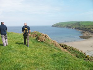
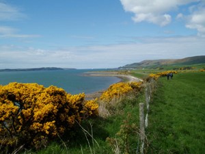
The route is approximately south to north and follows the east coast line of the Mull of Galloway peninsula. The distances listed here with the waymarker numbers are approximate and are from the Mull of Galloway.
Looking at the lighthouse from the Mull of Galloway car park the route commences by following the wall to the left (eastward) down to a fence where it passes through a gate and turns left (northwards) continuing on the seaward side of the fence dropping down into East Tarbet Bay and climbing back up to follow along the line of the cliff-top dyke. On reaching the Kirk Burn the route crosses a small sleeper bridge and then climbs up to the top of the slope to follow the fence line before dropping down to shore level and continuing to Maryport Caravan Site [waymarker No.1 – 6K]
Keeping to the coastline the trail enters Drummore Village via Cailiness Road, follows round the harbour [waymarker No.2 – 9K] and leaves via Shore Street. There is a general provisions shop, tearoom, hotel and toilets in Drummore.
Continuing on the footpath at Clashwhannan Caravan Site the route now keeps to the east verge of the A716 public road for 1 ½ kilometers before crossing over onto the access road at Grennan Farm. After turning right through a kissing gate the route keeps to the edge of the fields, then after a kissing gate it drops down to pass through Grennan Plantation to emerge through a further kissing gate and back across the A716 public road to the seaward side [waymarker No.3 – 13K]. Keeping to the seaward side of the road the trail continues along the coastline crossing Terally Bridge and passing through New England Bay Caravan Site to cross the bridge at Logan Mill [waymarker No.4 – 17K].
Following the coastline for a further one kilometer the trail turns left to enter Longrigg Plantation continuing north before climbing steeply to meet the access road to Longrigg House and Cottage where it turns left. The route continues on the access road to a kissing gate on the right giving access to a fenced off section of a field and onward through a further kissing gate to a small wood. At the north end of the wood the route crosses the A716 public road, turns right through a bridle gate in a field and follows the field edge before emerging through a kissing gate adjacent to the Barhill Farm access road and back across the public road to the seaward side. Following the coast for a short distance into a car park/picnic area [waymarker No.5 – 20K] the route passes through the village of Ardwell on the footway beside the public road.
Once through the village the trail returns to the shoreline for a further two kilometers before rejoining the road verge and then crossing the A716 road. The route continues over the road bridge and up a slope, through a wood and along a field edge. At the gate the route crosses back over the A716 road, turns right along a vehicle track and drops steeply down to the shoreline. Shortly after passing over the Cairnwiel Burn bridge the route to be followed depends on the state of the tide. The alternatives are, to continue on the shore, walk along the top of the concrete sea wall or follow the track on the left upwards to the public road where extreme care is required as there are no verges to walk on. The route continues along the shoreline of Sandhead Village where there is a general provisions shop, a tea room, a hotel and toilets. [waymarker No.6 – 25K].
The route proceeds northwards along the coast, crossing Sandmill Burn at the Sands of Luce Holiday Park and over and behind the sand dunes to cross Culmore Burn and into Clayshant Quarry. Continuing along the coast the route enters an area of whin bushes where it turns left to make its way inland and out of the quarry [waymarker No.7 – 29K].
Crossing the B7084 public road the route now follows quiet public roads northwards for the next five kilometers, passing the farms of Low Mye, High Mye, Mosscroft and Barnultoch to enter the access road to High Barnultoch Farm [waymarker No.8 – 34K].
Passing through a kissing gate the trail follows a fence line with stiles placed at intervals. These stiles are there to allow walkers to cross into the adjoining field in the event of there being a bull in the field. The route now enters a small wood with kissing gates at the entry and exit points. Continuing along a fence line and through a kissing gate the trail emerges onto a public road where it turns right and then left onto a track through a wood [waymarker No.9 – 36K].
Following this track for approximately two kilometers and crossing a public road after one and a half kilometers the route emerges on to a residential cul-de-sac (Westwood Avenue). It continues to cross trunk road A75 into Ladies Walk and on to the A77 trunk road. To finish, the trail turns left and continues over the railway bridge to the Tourist Information Office in Harbour Street [40.23K or 25 miles].
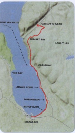
Route – Stranraer to Glenapp
The Loch Ryan Coastal Path commences at the Stranraer Tourist Information Office in Market Street, at the side of which is a plaque on top of a low wall marking the official opening on 7th August 2009 by Alex Fergusson MSP, Presiding Officer of the Scottish Parliament. At this location there is also the first of ten information boards sited at intervals along the route.
Having left the Tourist Information Office and passed the plaque and information board the route follows eastwards and northwards adjacent to the main road to Ayr (A77) around the south end of Loch Ryan. After 1¼ miles (2 km), at a gap in the concrete wall approximately 350 metres beyond the 30 mph derestriction sign and just before a ‘P 400 yds’ sign, the first waymarker post is sited where the route leaves the main road and follows the shoreline. From this point on the route is way-marked with the arrows showing the direction of the route.
Cognizance must be taken of the signs warning of sizeable waves created by the wash from the ferries using Loch Ryan.
A food outlet is available at the Balyett parking area adjacent to the shoreline.
The route continues on the shoreline to Ryan Bay Holiday Park. At the entrance to the park the route veers to the right and again follows the footway at the side of the main road as far as the entrance to Innermessan Farm; this being directly opposite the A751 junction. Turning left the route follows the Innermessan Farm road past the farm buildings and into the fields through the first of 12 kissing gates. On each of these gates the directional arrow is fixed on the top of the gate post.
The route continues around the western edges of two large fields to a track which links the main road to the shoreline. Here the route turns left and follows the track, continuing along the shore, crossing Beoch Burn and Several Burn on stepping stones. In the event of these burns being in spate alternative routes can be followed in the direction of the roadway (A77).
On reaching the boundary of Cairnryan Ferry Terminal the route rejoins the main road footway past the marshalling yard, terminal building and car park before returning to the shoreline and following the route of the old Cairnryan Military Railway. A restaurant and B & B establishments are available within Cairnryan village. At the entrance to the former shipbreaker’s yard and lighthouse the route again joins the main road until past the small cemetery, where it turns left before crossing the Glen Burn by way of a footbridge. Proceeding through the picnic area/lay-by where, picnic tables and toilets are available, the route then crosses the main road and climbs steeply up the road leading past Bonny Braes to Laird’s Hill.
Here the route crosses a cattle grid on to a stone track which continues to climb to the top of Little Laight Hill.
Passing through two kissing gates the route follows a fence line down to a small bridge over the Galloway Burn at the boundary of Wigtownshire and South Ayrshire. Passing through a kissing gate at the corner of a wood the route veers slightly downhill where it picks up a rough grass track which contours round the slope of the hill before joining a stone track leading to a telephone mast.
The route now turns uphill before turning off left to rejoin the grass track. The route continues to meander with the grass track until it returns to the edge of the wood where it drops down to a kissing gate which leads to a deep ravine formed by the March Burn. A steep drop takes the route down to a timber walkway and bridge before rising steeply up the opposite bank to a track. Here the route turns left following the track all the way down to the main road.
On crossing the main road the route turns right along the road verge to the north end of the Loch Ryan Coastal Path and the southern end of the Ayrshire Coastal Path. Walkers wishing to return to Stranraer by bus should wait at the bottom of the hill track where it is safer for a bus to stop.